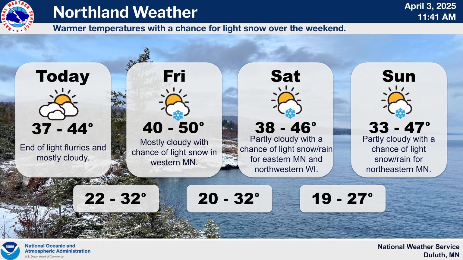
Severe storm threat today
Jun 10, 2026 05:45AM ● By Content Editor
From the National Weather Service in Duluth - June 10, 2026
Severe Weather Outlook for Wednesday, June 10. A severe storm threat is forecast for this afternoon and evening across the region. Numerous severe storms are possible across parts of east-central Minnesota and northwest Wisconsin with scattered severe storms elsewhere across the Northland. Primary Hazards: Damaging winds up to 70 mph, with local gusts up to 80 mph. Large hail up to 2 inches in diameter. A few tornadoes. Heavy rain and localized flash flooding Keep an eye on the sky and check back for updates as the daytime environment evolves.

SEVERE WEATHER UPDATE: The National Weather Service in Duluth is tracking two rounds of severe weather today, June 10. • Early This Morning: A line of scattered storms is moving northeast across the Northland, capable of producing 60-70 mph damaging wind gusts. Isolated 1” hail and a brief tornado are possible, particularly in the Brainerd Lakes area. • This Afternoon/Evening: A second, more widespread round of scattered to numerous severe thunderstorms is expected. All hazards are on the table, including large to very large hail, significant damaging winds, tornadoes, and localized heavy rain. Please note that the exact timing and intensity of the afternoon round will depend heavily on how this morning's storms and cloud cover clear out. Stay weather-aware today and ensure you have multiple ways to receive warnings!
![]()
Severe Weather Outlook for Wednesday, June 10. A severe storm threat is forecast for this afternoon and evening across the region. Numerous severe storms are possible across parts of east-central Minnesota and northwest Wisconsin with scattered severe storms elsewhere across the Northland. Primary Hazards: Damaging winds up to 70 mph, with local gusts up to 80 mph. Large hail up to 2 inches in diameter. A few tornadoes. Heavy rain and localized flash flooding Keep an eye on the sky and check back for updates as the daytime environment evolves.
SEVERE WEATHER UPDATE: The National Weather Service in Duluth is tracking two rounds of severe weather today, June 10. • Early This Morning: A line of scattered storms is moving northeast across the Northland, capable of producing 60-70 mph damaging wind gusts. Isolated 1” hail and a brief tornado are possible, particularly in the Brainerd Lakes area. • This Afternoon/Evening: A second, more widespread round of scattered to numerous severe thunderstorms is expected. All hazards are on the table, including large to very large hail, significant damaging winds, tornadoes, and localized heavy rain. Please note that the exact timing and intensity of the afternoon round will depend heavily on how this morning's storms and cloud cover clear out. Stay weather-aware today and ensure you have multiple ways to receive warnings!
⚠️ ATTENTION BWCA CAMPERS ⚠️ Strong to severe thunderstorms are possible across the Boundary Waters Canoe Area Wilderness this afternoon and evening, Wednesday, June 10. Timing: The highest probability for severe weather is between 3:00 PM and 9:00 PM. Hazards: Damaging wind gusts and large hail (up to golf ball sized, 2"+ in diameter) are the primary threats. If you are currently camping or planning to head out, take extra precautions right now to secure your campsites. Have a plan to seek safe shelter or consider altering your travel plans until the storms pass. Stay weather aware!
For additional weather details, go to https://www.weather.gov/dlh/weatherstory

