Winter Weather 101: 5 Things To Know To Be Prepared For The Season
Nov 25, 2022 10:06AM ● By Editor
Forecasting winter weather can be tricky and can cause dangerous, quickly changing conditions, so it's important to understand the nuances in all things winter so you will be able to prepare for the worst.
With that in mind, here are five things you need to know about winter weather to be prepared.
When there is a winter storm on the horizon everyone wants to know how much snow are they going to receive. However, the accuracy of snowfall forecasts more than a couple of days out from the event is not very reliable.
Computer model forecasts can change multiple times a day as new data about the atmosphere is received. These changes can be significant. For instance, well before a winter storm pounds the Midwest it could exist as a weather disturbance over the Pacific Ocean, an area we have little data about. With less initial data it's more difficult to predict the future path and intensity of any given storm.
So meteorologists examine multiple numerical models and their trends over time, using knowledge of each model's strengths and biases. These forecasts tend to be more accurate than any one individual model forecast.
The takeaway: Don't take a first snow or ice forecast as the final answer and be sure to check back for forecast updates as the potential winter event approaches.

Low-pressure systems can track quickly across the U.S. in the winter, bringing rapid changes in conditions over a short period of time and distance.
The track of a system often determines the type of precipitation that falls in a particular location. The rain/snow line, for example, can be tricky to forecast and its location can change during the event.
Sometimes snow, sleet or ice can fall sooner than anticipated if the system moves faster than forecast or if the atmosphere is colder than originally expected.
In short-term forecasts, heavy bursts of snow or snow squalls can develop. The location of these squalls is difficult to determine ahead of time. Snow squalls have historically been a contributor to major highway pileups due to their brief but intense snowfall rates that drop visibility suddenly.
The NWS issues snow squall warnings, so it is important to be able to receive these short-term warnings and heed them.
Snow squalls can occur where there is no major large-scale winter storm, including lake-effect snow events.
These lake-effect snow events are notorious for rapid changes. Impacts from lake-effect snow can be very localized because the area that experiences heavy lake-effect snow can be fairly small. One location may see a foot or more of snow, while a few miles away there is no snow at all.
Another factor to consider while driving is that bridges and overpasses freeze quicker and become very slippery before other road surfaces.
Even light snow can be dangerous. It is important to not focus on the specific snowfall amounts forecast but consider possible impacts such as wind, ice and the intensity of the precipitation and its duration.
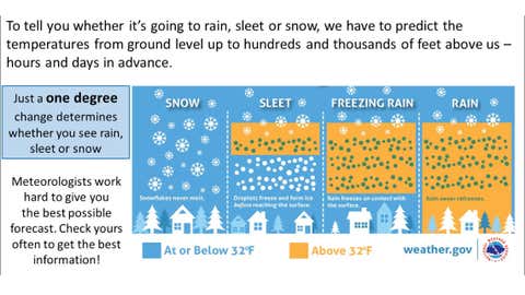
Determining the precipitation type during an event can be very difficult as small changes in temperature can have big implications.
Sleet is frozen precipitation that falls as ice pellets and accumulates similar to snow. Freezing rain looks like rain, but freezes when it makes contact with roads, trees, power lines and other structures.
Even a light accumulation of freezing rain can create dangerous conditions. Significant accumulations of a quarter inch of ice, often called an ice storm, can create widespread power outages, damage trees and make roads impassable.
The temperature at different levels in the atmosphere determines the precipitation type that reaches the ground.
Sleet forms when snow aloft passes through a warm layer that melts it into rain but then refreezes into ice pellets as it falls into a deep and/or very cold layer of below-freezing air near or just above the surface.
Snow reaches the ground when there is no warm layer present, or when above freezing temperatures are in a relatively shallow layer at the surface.
When there's a chance for winter precipitation the National Weather Service (NWS) will issue alerts depending on the timing of the threat as well as the type, amount and the potential impacts of that precipitation.
Winter storm watches are issued when winter weather could be of high impact within 48 hours. Watches do not guarantee that significant winter weather will occur but hint at the potential. This includes the potential for heavy snow, sleet, freezing rain and lake-effect snow.
It is also important to note that the criteria for what is significant vary by region. A few inches of snow in the Midwest is not likely to be significant but those totals are hazardous in areas like the South that are less prone and prepared for snow.
A watch can then be upgraded to a winter storm warning or a winter weather advisory. It can also be dropped with no advisories or warnings issued if conditions no longer appear to warrant alerts.
Winter storm warnings are posted when a high impact event is anticipated within the next 12 to 18 hours. Warnings are for heavy snow, sleet or lake-effect snow and can indicate dangerous and life-threatening conditions.
A winter weather advisory is issued when snow, sleet or freezing rain will likely cause a significant inconvenience but not serious enough to reach warning level.
If the combination of snow and wind may reach blizzard criteria then a blizzard warning is issued. For a blizzard to occur snow and/or blowing snow must reduce visibility to a quarter mile or less for at least 3 hours and sustained winds or frequent gusts of at least 35 mph must be observed.
An ice storm warning is posted when a quarter inch or more of ice accumulation is anticipated.
The weather alerts issued by the NWS will include what conditions are expected, along with when and where. The alerts issued by the NWS are broadcast across the media, including on weather.com and The Weather Channel app.
How To Prepare
Before a winter storm impacts your area check to see if you have the supplies you need.
Be sure to have flashlights, batteries, extra food and water, medications, first-aid supplies, a battery-powered radio and a heat source. Remember to never run a generator in an enclosed space.
If you have pets, have extra food, plenty of water and a warm shelter for them.
When driving in wintry conditions, take it slow and avoid sudden stopping or changes in direction.
Before taking a trip, check all fluids levels in your car, as well as its lights and windshield wipers. Keep your gas tank near full to avoid ice in the tank and fuel lines. Let someone know your plans and check road conditions.
Keep a shovel, sand or cat litter for traction, windshield scraper and brush, tow rope, tool kit, booster cables, a compass and roadmaps in your car in case you get stuck or lost.
Other supplies that are good to have on hand if you get stranded are a phone, charger, batteries, blankets, flashlight, first aid kit, non-perishable food, extra clothes, candles, matches and a water container. When heading outdoors in the winter, dressing warmly in layers is recommended.

To see the original post and read related stories, follow this link to the Weather Channel website. https://weather.com/safety/winter/news/2022-11-23-winter-weather-what-to-know

