How a rare 'triple dip' La Nina could impact Minnesota's winter
Sep 05, 2022 09:38AM ● By Content Editor
By Sven Sundgaard - Bring Me The News - September 4, 2022
Double dipping is a social faux pas at any party but can you imagine a triple dipper? That’s what we have going on this year with La Nina. To have three consecutive La Nina patterns is pretty rare. It’s only happened twice since 1950, in fact.
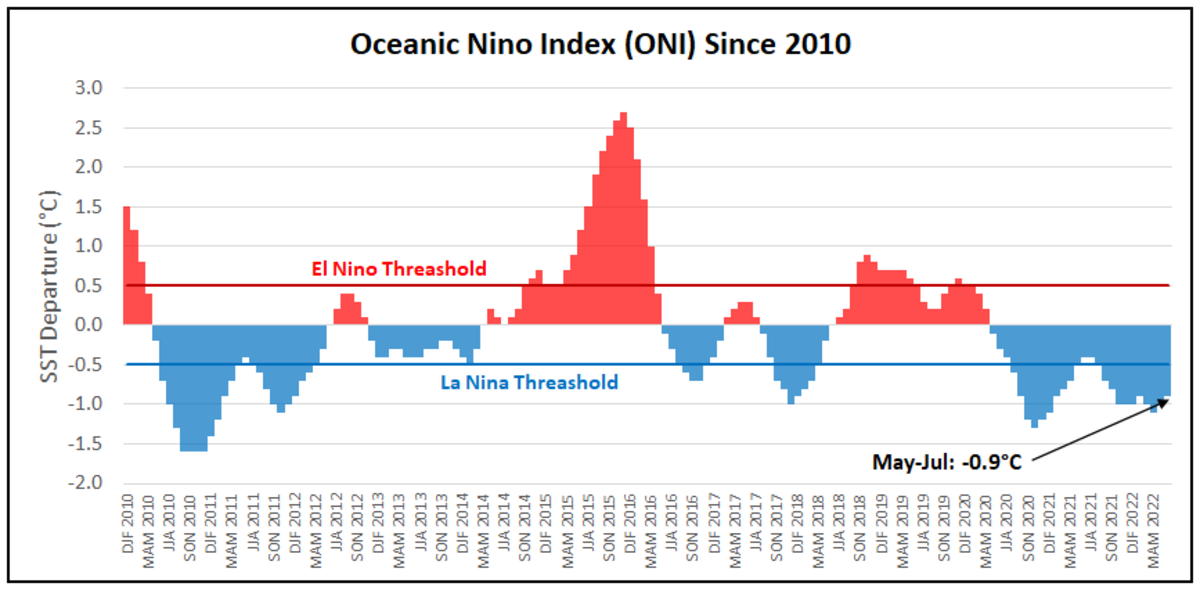
El Nino (red) and La Nina (blue) periods since 2010). NOAA
One advantage of three consecutive La Nina patterns is that perhaps the public is a bit more familiar with what La Nina is and some of its impacts. For Minnesota, the biggest effects of El Nino/La Nina is on our winters. For the globe, it can result in a more active Atlantic hurricane season (La Nina), Australian floods (La Nina) or droughts (El Nino), droughts in Texas (La Nina), and heavy rains for California (El Nino).
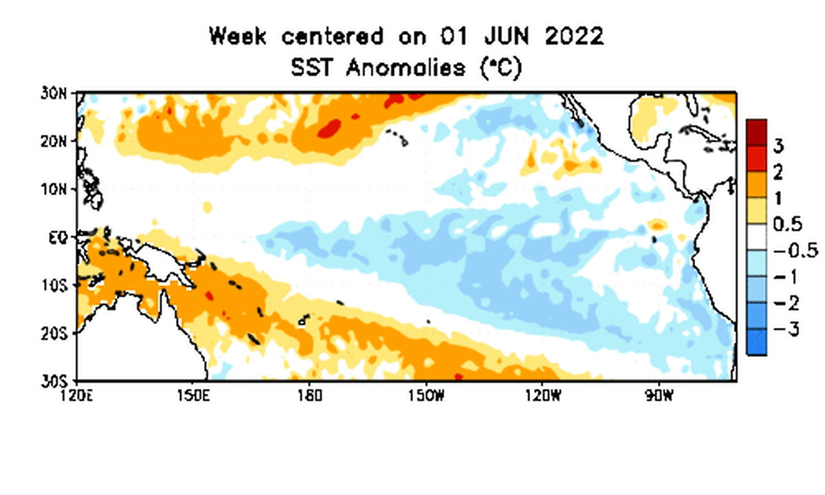
Sea surface temperature anomalies or difference from normal. Note the blue, or cooler than normal conditions in the eastern Pacific associated with La Nina conditions. NOAA
Sometimes I worry about talking about winter too early, but perhaps with the heat this summer some will welcome it. And we need to talk about winter because La Nina/El Nino can substantially impact our winter weather patterns.
NOAA is forecasting a 60% chance that La Nina persists into the winter of 2022-2023. To better understand the implications La Nina has on winter we must first understand what the heck it really is and how it impacts global circulation patterns.
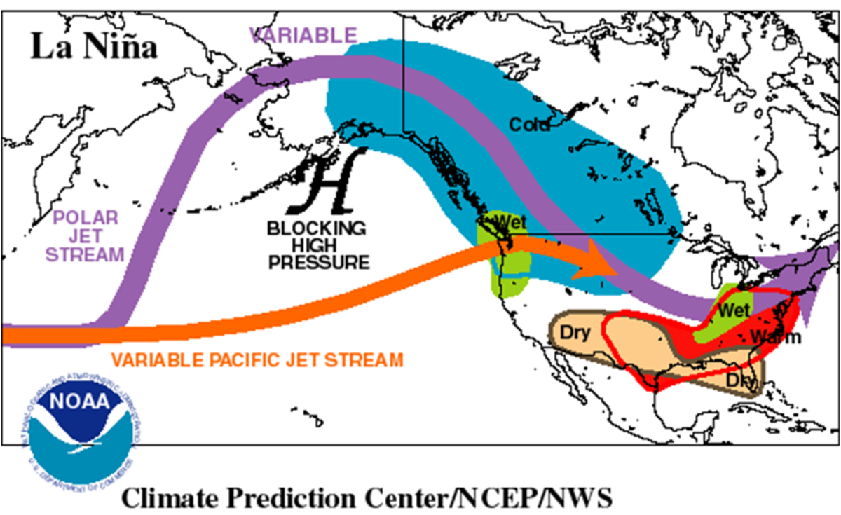
What is La Nina?
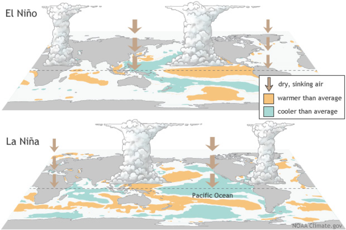
La Nina, literally "the girl" is the opposite of her brother, ‘El Nino’ part of what meteorologists and climatologists call ENSO (El Nino/Southern Oscillation). El Nino denotes warmer than normal waters off the west coast of South America (namely Peru/Ecuador) and La Nina is the opposite, with colder than normal waters off the coast of South America.
Despite being a few thousand miles from Minnesota, these patterns have a big impact on our weather and global weather patterns. Essentially, the Pacific Ocean’s warmest waters slosh back and forth depending on the direction of the trade winds. These winds typically blow from east to west near the equator. As a result of that surface flow, water is forced upward from the depths around western South America. We call this upwelling, and this keeps waters off the west coast of South America pretty chilly, even at the equator. As the air and water flow east to west the surface ocean waters are warmed in the tropical sun and accumulate around Australia, Indonesia and Papua New Guinea. When these winds weaken, or even reverse, this allows waters to warm in the eastern tropical Pacific.
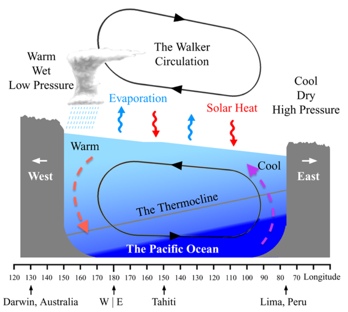
The reason this all matters is because where the warmest tropical Pacific ocean waters are, you have the most convection (thunderstorm activity) over large areas. What goes up, must come down, and in this case it’s air. This whole pattern can alter or reverse the flow of large scale patterns affecting weather here in little old Minnesota even.
NOAA
While El Nino winters have a strong correlation to mild winters in Minnesota (about 75% of the time), La Nina winters have a little weaker correlation. In La Nina winters, about 60% of the winters are cooler, but there’s more variation than in an El Nino pattern.
NOAA
The last two winters have been La Nina winters. While 2021-2022 was actually slightly milder than normal, the previous winter of 2020-2021 was more significantly chilly (notably January and February). For some context, the winter of 2016-17 was a strong El Nino winter and we had a string of 60s in late February and almost no snow on the ground much of the winter.
Early winter 2022-2023 predictions?
Forecast two weeks ahead let alone two seasons ahead is risky business and a lot of factors go into a seasonal pattern. Take last winter for example: Yes it was chilly in January and February but December was VERY mild (remember the tornadoes?) and March was pretty normal.
The official forecast from NOAA’s Climate Prediction Center calls for equal chances of it below or above normal (remember, ‘normal’ refers to the modern 30-year average, not the historic averages). NOAA's December, January, February map shows a temperature pattern that indicates a weak La Nina. They’re hedging their bets at this point until we get deeper into fall and see what the tropics have in store.
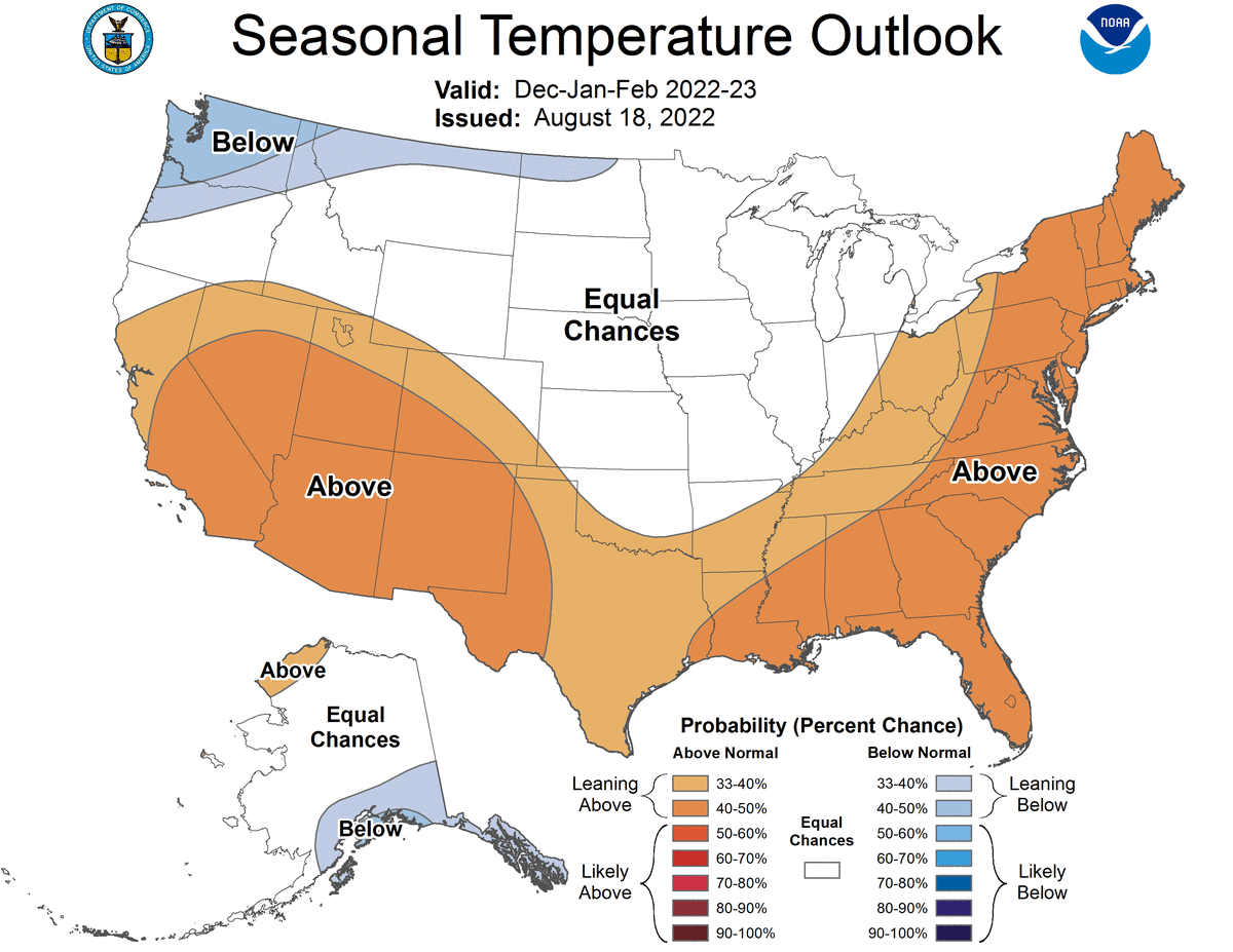
NOAA
The European model thinks it will be perhaps a bit milder, and so does the Canadian model, though the Canadian model at this point also reflects more of a weak La Nina pattern, which makes a bit more sense.
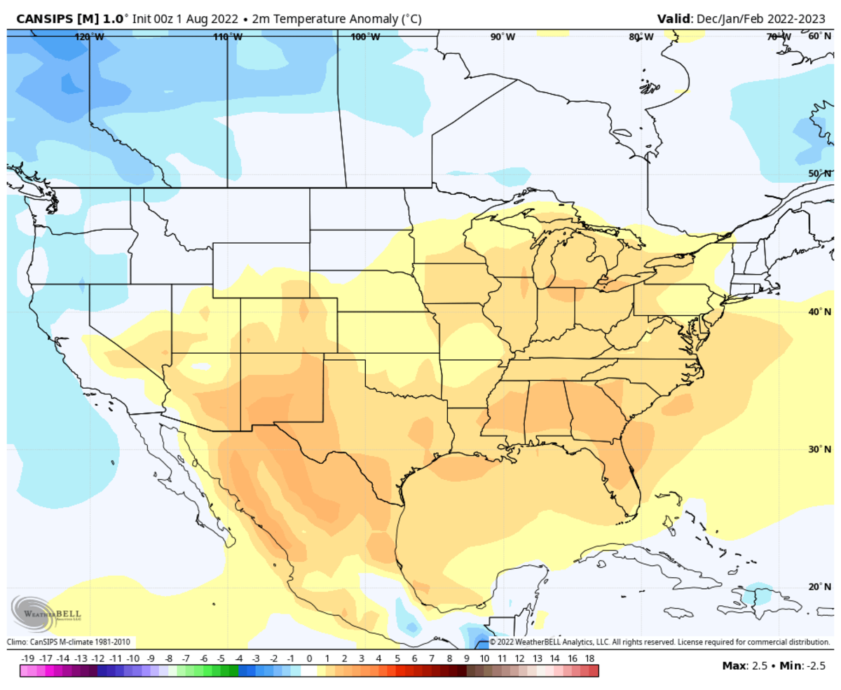
WeatherBell
The NMME (North American Multi-Model Ensemble), which is an average of a variety of North American models, shows a very similar outcome:
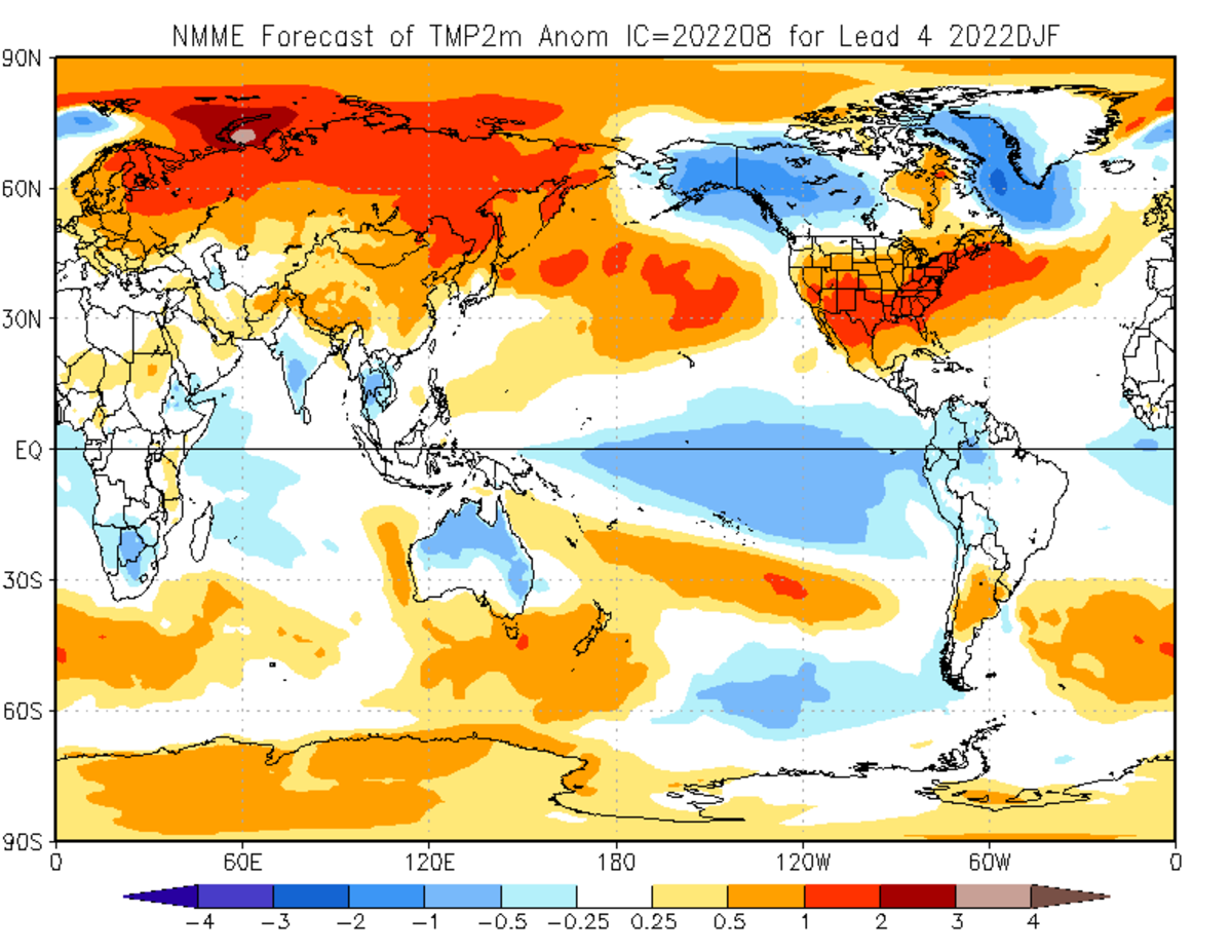
NOAA
Remember, about 60% of the time a La Nina winter results in cooler conditions for the Twin Cities. But that means 40% of the time it’s normal or milder.
Statistically speaking, this winter could go either way since 2020-21was just barely above normal and last winter was colder than normal. Only time will tell us the answer to the 2022-2023 winter riddle.
To read this original story and more news, follow this link to the Bring Me The News website.

